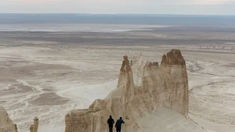
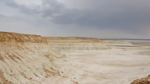
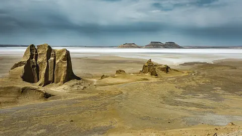
01 Bozzhyra and the wild landscapes of Mangystau Bozzhyra's chalk spires on the Ustyurt edge are the region's signature view, about 298–300 km from Aktau and off-road only.
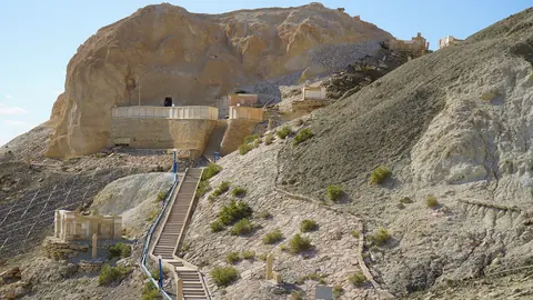
02 Beket-Ata underground mosque at Oglandy An underground mosque cut into a chalk cliff at Oglandy, 4–5 hours from Aktau, with a pilgrims' guesthouse for the night.
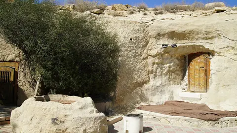
03 Shopan-Ata A rock-cut mosque with a 7.1 by 5.1 m hall and graves from the 10th to 19th centuries, on the road to Beket-Ata.
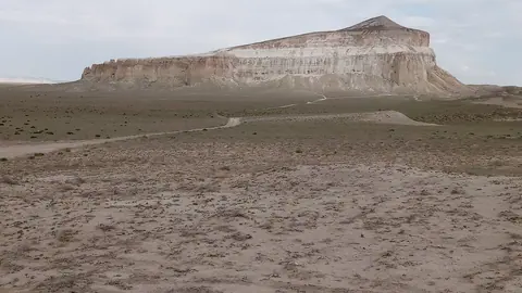
04 Sherkala Mountain A lone 332 m limestone mountain shaped like a yurt or a lying lion, 18 km from Shetpe.
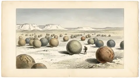
05 Torysh Valley of Balls Stone concretions up to 4 m across scattered over the steppe, 50–60 km from Sherkala.
06 Karagiye Depression, the deep karst basin near Aktau The lowest land in Kazakhstan at 132–134 m below sea level, about 56 km from Aktau in a straight line.
07 Fort Shevchenko, the old Caspian fort town on the Mangystau coast A Caspian town where Taras Shevchenko served his exile in 1850–1857, with a museum and 19th-century lighthouses.
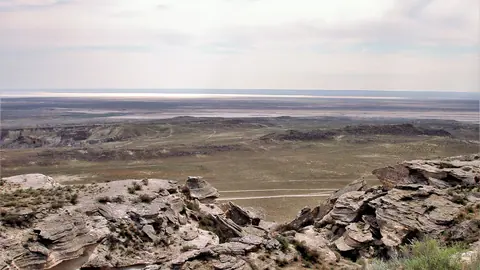
08 Ustyurt Plateau A strict reserve of 2,230 km² founded in 1984, with plateau cliffs over 200 m high.
09 Karynzharyk Sands About 2,000 km² of sand hills and salt flats in a remote hollow with no facilities we could confirm.
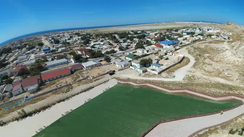
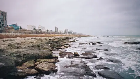
10 The Caspian Sea at Aktau A seafront walk of about 5 km with cliffs, beaches and sea water around 18 °C in season.
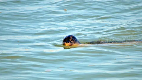
11 The Caspian seal The Caspian's only seal, endemic to this sea, has declined by more than 90% in about a century.
The Mangystau region sits in Kazakhstan’s far southwest, on the eastern shore of the Caspian Sea, and the port city of Aktau is the starting point for almost everything here. Its sights split into two groups: day trips within roughly 50–180 km of Aktau, and remote desert sites near the Ustyurt Plateau about 280–300 km away that need an off-road vehicle and a long day or more. Spring and autumn are the seasons that work for nearly all of them.
Mangystau at a glance: distance decides the trip
How far a place is from Aktau decides what kind of trip it is, more than what it looks like. The table below compares the places this guide covers. Where a distance was computed in a straight line it says so; the other figures are given as distances from Aktau without further detail, and the road will be longer than any straight line.
| Place | Distance from Aktau | Trip length | Best months | What it is |
|---|---|---|---|---|
| Karagiye Depression | about 56 km, straight line | half day | Apr, Oct | basin 132–134 m below sea level |
| Torysh | 90–150 km | day | May, Sep | field of stone balls up to 4 m |
| Fort-Shevchenko | about 121 km, straight line | day | May–Jun, Sep | Caspian fort town, Shevchenko museum |
| Sherkala | 175–180 km | day | May, Sep | lone limestone mountain, 332 m |
| Shopan-Ata | about 179 km, straight line | weekend | Apr, Oct | rock-cut mosque, old necropolis |
| Karynzharyk | about 275 km, straight line | weekend | Apr, Oct | sand hills and salt flats |
| Beket-Ata | 280–285 km | long | Apr–May, Sep | underground mosque at Oglandy |
| Ustyurt Reserve | about 284 km, straight line | weekend | Apr, Oct | plateau edge, cliffs over 200 m |
| Bozzhyra | 298–300 km | long | May, Sep | chalk fangs on the Ustyurt edge |
| Aktau beaches | in the city | day | Jul–Aug | Caspian seafront, about 5 km walk |
If you have one free day, the top half of the table is realistic. The bottom half means committing two or more days and arranging an off-road vehicle.
The Ustyurt edge is the reason most people come, and the hardest part
The most dramatic landscapes of the Mangystau desert lie on the western cliffs of the Ustyurt Plateau, around 280–300 km from Aktau. Bozzhyra is the headline: white chalk spires on the plateau edge, reached by off-road vehicles only, with no mobile signal. Summer days there go above +40 °C.
Further south, the Ustyurt Reserve protects 2,230 km² of plateau and the Kenderlisor depression, near the borders with Uzbekistan and Turkmenistan. It was set up in 1984 and is a strict nature reserve, so access rules need checking before you plan. Karynzharyk, a desert hollow of about 2,000 km² between the Mangyshlak peninsula and Ustyurt, is the least documented: low sand hills of 5–15 m, salt flats, and no facilities we could confirm.
Getting this wrong is costly. A breakdown or a wrong turn out here, in heat and without signal, is a safety problem rather than an inconvenience.
Beket-Ata and Shopan-Ata are pilgrimage sites first
The two rock mosques of Mangystau are working sacred places, and visitors share them with pilgrims. Beket-Ata is cut into a chalk cliff at Oglandy on the edge of the Ustyurt plateau, 280–285 km from Aktau, a drive of 4–5 hours. There is a pilgrims’ guesthouse, and photography inside the mosque is not allowed.
Shopan-Ata lies on the way, about 179 km from Aktau in a straight line. Its mosque is hollowed out of a ravine wall, with a hall of 7.1 by 5.1 m, and around it spreads a necropolis with graves from the 10th to the 19th century. Both mosques are described as part of the UNESCO World Heritage listing of Mangystau’s rock mosques from 2026.
Combining the two in one trip is the natural plan: Shopan-Ata as a stop on the road, Beket-Ata as the destination, with a night at the guesthouse instead of driving back the same day.
Day trips from Aktau: Sherkala, Torysh, Karagiye and Fort-Shevchenko
Four places can be done in a day from Aktau, and two of them pair well. Sherkala, a lone limestone mountain of 332 m that looks like a yurt from one side and a lying lion from the other, stands 18 km from the village of Shetpe. Torysh, with stone concretions from 10–15 cm to 4 m across scattered over the steppe, is 50–60 km from Sherkala. Torysh has no protected status.
Karagiye is the shortest outing: a dry karst basin about 56 km from Aktau in a straight line, dropping to 132–134 m below sea level, the lowest land in Kazakhstan. The Aktau–Zhanaozen highway crosses its floor.
Fort-Shevchenko is the history option, on the Tupkaragan cape about 121 km from Aktau in a straight line. Russian fortifications stood here from 1717, the fort town dates from 1846, and the Ukrainian poet Taras Shevchenko served his exile here in 1850–1857. It has a Shevchenko museum, 19th-century lighthouses and Palaeolithic sites nearby.
When to go: spring and autumn, with the sea as the summer exception
April–May and September–October are the months when almost every place in Mangystau is rated good or best. Summer is the problem: Sherkala and Bozzhyra both pass +40 °C, and Ustyurt reaches almost 38 °C by day. In the ratings, winter is off or only possible for the remote desert sites. Our Mangystau weather by month puts numbers on it: near Bozzhyra, 22 days in July reach 35 °C or more, while April and October each bring 23–24 comfortable days.
| Period | Desert and Ustyurt sites | Rock mosques | Coast and Aktau |
|---|---|---|---|
| Dec–Feb | off or barely possible | possible | no swimming; seals winter far to the north |
| Mar | possible | possible | cool |
| Apr–May | best | best | Fort-Shevchenko best in May |
| Jun–Aug | heat above +40 °C at some sites | possible | swimming season |
| Sep–Oct | best | best | Fort-Shevchenko best in Sep |
| Nov | possible at best | possible | off-season |
The sea flips the pattern. Swimming at Aktau starts around late May, with water averaging about 18 °C in season. Summaries differ on whether the season ends in August or runs into September, so treat September swimming as uncertain. A summer trip is best built around the coast, with desert outings only at dawn if at all.
What is hard for a visitor without a car or Russian
The remote half of Mangystau cannot be reached by public transport as far as we could confirm, and Bozzhyra requires an off-road vehicle. Aktau airport lies 24–25 km north of the city, but we could not confirm flight routes, car hire with off-road vehicles, or drivers who speak English.
There is a car entry fee at Bozzhyra, and Ustyurt is a strict reserve whose visitor rules we could not verify. Mobile signal is absent at Bozzhyra and likely patchy elsewhere in the deep desert. For many foreign visitors this means hiring a driver with a suitable vehicle; we do not recommend or rate any operator, so compare options yourself and ask about water, fuel and recovery plans.
- Public transport from Aktau to any of the desert sites
- Visitor rules and permits for the strict Ustyurt Reserve
- Availability of off-road vehicles and English-speaking drivers in Aktau
- Current road conditions to Bozzhyra, Beket-Ata and Karynzharyk
- Whether the swimming season at Aktau lasts into September
Frequently asked questions
Where is the Mangystau region?
What is the Mangystau desert like?
What is the Mangystau plateau?
Can I visit Mangystau without a tour?
How many days do I need for Mangystau?
In this section: Where to go in Kazakhstan
- Almaty cable cars: which lines run, where they go and what to check first
- Glamping in Kazakhstan and near Almaty: Night Temperatures, Park Rules, What to Ask
- Horse riding in Kazakhstan: where to ride and what to expect
- Ice skating in Almaty: free city rinks and what is known about the 2026/27 season
- Stargazing in Kazakhstan: meteor shower calendar 2026–2027 and dark skies near Almaty
- Aktobe Kazakhstan: four remote steppe places and the weather that decides when to go
- Alakol, Balkhash or Kapshagay: where to spend a holiday by the water
- Ancient cities of Kazakhstan: nine sites and what is left to see
- Beach lakes in Kazakhstan: which lake suits a summer swim
- Burabay or Bayanaul: which to choose for a northern summer
- Canyons near Almaty: what actually fits into one day
- Caves and underground mosques of Kazakhstan: which one fits your trip
- Charyn Canyon and the other canyons of Kazakhstan: which one to choose
- Charyn or Kolsai with Kaindy: where to go if you have one day
- Choosing a desert in Kazakhstan: dunes, chalk cliffs and a vanished sea
- Day trips from Almaty, Kazakhstan: lakes, peaks, kurgans and ski slopes within a day
- Eagle hunting in Kazakhstan: where to see Kazakh eagle hunters
- From the Kaindy Lake underwater forest to Altai taiga: choosing a forest trip in Kazakhstan
- Hiking in Kazakhstan: where to walk, from Almaty's day trails to the Altai
- Hot springs in Kazakhstan: how to choose between six thermal spas
- Kazakhstan in April: where the season peaks and what can wait until May
- Kazakhstan in August: where the weather and the season line up
- Kazakhstan in July: which mountains, lakes and cities suit the month
- Kazakhstan in June: weather, lakes and where to go this month
- Kazakhstan in March: where to go while the mountains hold snow and the south warms up
- Kazakhstan in May: the places our guide rates at their best this month
- Kazakhstan mountains: ranges, peaks and where to go
- Kazakhstan nature in 20 places: lakes, peaks, canyons and hot springs
- Kazakhstan or Kyrgyzstan: which to choose for a mountain trip
- Kazakhstan tourist attractions: 50 places to visit
- Kazakhstan travel in February: ski slopes, hot springs and warm indoor sights
- Kazakhstan travel in January: ski slopes, hot springs and warm indoor sights
- Kazakhstan without a car: places you can reach by city bus, cable car and on foot
- Lakes near Almaty: how Big Almaty Lake, Kaindy, Issyk and the reservoirs compare
- Lakes of Kazakhstan: 15 places to visit
- Mosques in Kazakhstan: which to visit and how to behave inside
- Mountains in Almaty and around it: how to pick the right one for your trip
- Museums in Kazakhstan: which to pick by theme, and what to check first
- Places in Kazakhstan without the crowds, and how to choose between them
- Reservoirs in Kazakhstan: the largest, and the few worth a trip
- Sacred places of Kazakhstan and how to choose which to visit
- Seven Wonders of Kazakhstan: two lists and no confirmed result
- Shymbulak or Oi-Qaragai: which resort near Almaty to choose
- Skiing in Kazakhstan: how Shymbulak compares with the other ski resorts near Almaty and in the Altai
- Tamgaly petroglyphs and the other rock art sites of Kazakhstan
- The Kazakh steppe: where to see it, and where you are allowed in
- The Mausoleum of Khoja Ahmed Yasawi and the other shrines and Silk Road cities of Kazakhstan
- The most photogenic places in Kazakhstan, and the month each one looks its part
- The Silk Road in Kazakhstan: three corridors and where to see them
- Tian Shan in Kazakhstan: where the range runs and which part to visit
- Top 10 nature destinations in Kazakhstan
- Trips from Aktau, Kazakhstan: the coast, the desert and the Mangystau hills
- Trips from Karaganda, Kazakhstan: Gulag memorials, granite hills and steppe lakes
- Trips from Kyzylorda: the cosmodrome, the Turkistan shrines and the Syr Darya ruins
- Trips from Oskemen: nine places in East Kazakhstan and when each one works
- Trips from Pavlodar: where to go and how far each place is
- Trips from Taldykorgan: where to go in the Dzungarian Alatau, Altyn-Emel and beyond
- Trips from Taraz: what to see in the city, nearby and further across the south
- Trips from Turkistan, Kazakhstan: ruined cities, shrines and the Karatau hills
- Turgen waterfall, Burkhan-Bulak and Butakovka: choosing a waterfall in Kazakhstan
- Waterfalls near Almaty: how to choose between Turgen and Butakovka
- Weekend trips from Astana: 5 places in nature
- What to do in Almaty in winter, from ski slopes to hot springs
- What to see around Karaganda, Kazakhstan: Gulag memory, granite hills and steppe lakes
- What to see in Akmola Region: lakes, steppe hills and a Gulag memorial
- What to see in Almaty Region: lakes, canyons and mountains around Almaty
- What to see in East Kazakhstan Region and when to go
- What to see in Kyzylorda Region: a spaceport, a shrunken sea and a singing monument
- What to see in Turkistan, Kazakhstan: shrines, ruined cities and spas of the Turkistan Region
- What to see in Zhambyl Region: Taraz's old tombs and the Moiynkum sands
- What to see in Zhetysu Region, and which trip suits you
- Where to go from Almaty for a day or a weekend
- Where to go from Kokshetau: four lakes nearby, and the capital further out
- Where to go from Konaev: the Ili River, Saka kurgans and Almaty's mountains
- Where to go from Semey: eight trips, from the Abai Museum to the Bayanaul lakes
- Where to go from Shymkent: shrines, Silk Road ruins, canyons and spas
- Where to go in Kazakhstan for Nauryz: nature on the 21–23 March holiday
- Where to go in Kazakhstan in autumn
- Where to go in Kazakhstan in December: ski slopes, hot springs and warm indoor sights
- Where to go in Kazakhstan in November, when the weather favours hot springs and indoor sights
- Where to go in Kazakhstan in October: mountain trails near Almaty and the southern shrines
- Where to go in Kazakhstan in September, and what the weather allows
- Where to go in Kazakhstan in spring
- Where to go in Kazakhstan in summer
- Where to go in Kazakhstan in winter
- Where to go in Kazakhstan with kids, and which month suits each place
- Where to go on Kazakhstan's Caspian Sea coast, and when
- Where to see Kazakhstan wildlife: eight places compared
- Which peaks in Kazakhstan suit a hiker's first summit
