


If you are looking at Aktobe, Kazakhstan, as a base, this guide covers four places in the surrounding region: Abat-Baitak Mausoleum, the Aktolagai chalk cliffs, the Mugodzhar Mountains and the Irgiz-Turgai Reserve. All four rate May and September as their best months. Each is a long, self-planned trip, and one of them may not be open to visitors at all.
Four places in Aktobe Region, compared
The closest option to Aktobe city is a historic mausoleum; the farthest is a saiga reserve whose signs say entry is forbidden. The table sets them side by side so you can match a place to the time and effort you have.
| Place | What it is | Distance | Best months | Main caveat |
|---|---|---|---|---|
| Abat-Baitak | Brick mausoleum and necropolis | about 92 km from Aktobe, straight line | May–June, September | Active pilgrimage site |
| Mugodzhar Mountains | Low ridges at the southern end of the Urals | about 207 km from Aktobe, straight line | May, September | Access details unconfirmed |
| Aktolagai | 90 km chalk ridge with fossils | about 252 km from Atyrau, straight line | May, September | Remote, plan your own route |
| Irgiz-Turgai Reserve | Protected steppe and lakes for saiga | about 498 km from Aktobe, straight line | May, September | Boundary signs say entry is forbidden |
Read the distance column with care. These are straight-line figures, not road distances, and the Aktolagai page measures from Atyrau rather than Aktobe. Real driving distances will be longer, and we could not confirm any of them.
Abat-Baitak is the most realistic trip from Aktobe city
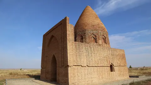
At about 92 km from Aktobe in a straight line, Abat-Baitak in Khobda district is the nearest of the four. Its brick mausoleum, about 9.52 by 9.8 m, has an 11-sided drum under a conical dome. Around it lies a cemetery used from the 14th to the early 20th century, with more than 200 carved kulpytas, the stone grave markers of the steppe.
This is architecture of the Younger Zhuz, and it is still a place of pilgrimage. Visit as you would any place of worship: quietly, and with attention to people who have come to pray. It also has the longest good season of the four, rated good to best from April through October.
Mugodzhar and Aktolagai are for geology and open space
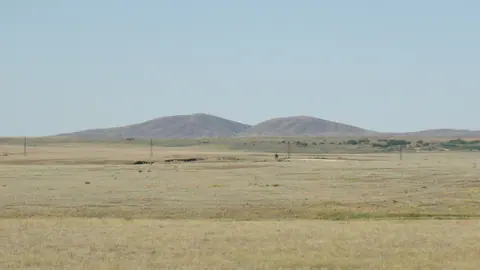
Neither of these is about big scenery in the mountain sense. The Mugodzhar Mountains run for about 200 km and top out at just 657 m, yet they form the watershed between the Caspian and Aral basins, and the Emba and Or rivers, plus tributaries of the Irgiz, begin here. Go for solitude and the sense of standing where the Urals end.
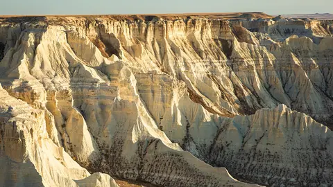
Aktolagai, in Baiganin district, is a white chalk ridge 90 km long and 5–10 km wide, reaching up to 302 m, between the Sagiz and Zhem rivers. Weathering has cut the chalk into shapes that locals have named, and Cretaceous shark teeth turn up on the slopes of this former seabed. Both pages flag the same problem: we could not confirm roads or access, so you will be planning the route yourself.
Irgiz-Turgai Reserve: check permission before anything else
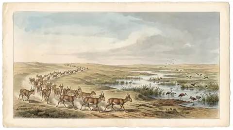
The Irgiz-Turgai Reserve was created in 2007 to bring back the Betpak-Dala saiga antelope, and it covers a vast area of steppe and lakes in Irgiz district. It is also the hardest place here to plan. Its boundary signs state that entry is forbidden, and we could not confirm any visitor permit procedure.
At about 498 km from Aktobe in a straight line, this is an expedition, not a day out. Do not set off on the strength of the season ratings alone; settle the question of access first.
Aktobe Kazakhstan weather: what the seasons mean for these trips
We could not confirm temperature or rainfall figures for Aktobe city or the region, so this page relies on the season ratings of the four places. They agree closely: May and September are the peak months everywhere, and December to February is rated off at every site.
| Month | Rating across the region | What it means |
|---|---|---|
| Jan–Feb | Off | Not sensible at any of the four places |
| March | Possible at three sites | Mugodzhar still rated off |
| April | Good at three sites | Early option, Mugodzhar only possible |
| May | Best everywhere | The safest month to plan around |
| June | Good at two sites, best at Abat-Baitak | Aktolagai drops to possible |
| July–August | Possible at three sites | Abat-Baitak stays good |
| September | Best everywhere | The second peak window |
| October | Good at three sites | Mugodzhar drops to possible |
| November | Possible at three sites | Mugodzhar rated off |
| December | Off | Not sensible |
The practical upshot: if you can only pick one month, pick May or September. A midsummer trip works best if Abat-Baitak is your main goal, since it is the only place still rated good in July and August.
What is hard here without a car or Russian
None of the four place pages could confirm public transport, organised access or road conditions. Two of them say outright that the route is yours to plan. For a visitor without a car or Russian, that means arranging a driver and local help before you arrive, and building in time for long distances across open steppe.
We also could not confirm where in Kazakhstan Aktobe sits relative to Almaty or Astana in travel time. Check how you will reach Aktobe itself before committing to any of these trips.
- Temperature and rainfall figures for Aktobe city and the region
- Road conditions and driving times to all four places
- Whether any visitor permit exists for the Irgiz-Turgai Reserve
- Public transport or organised access from Aktobe
- Travel time from Almaty or Astana to Aktobe