Kazakhstan roads in winter: blizzards and closures over 25 years
The Astana–Karaganda highway gets more blizzard days than any other main road in Kazakhstan: about 11 a winter. March is as stormy as December on the northern roads. We counted blizzard days at 12 highway points over 25 winters of ERA5 reanalysis and checked them against real closures.
Winter roads in Kazakhstan are passable most days, but blizzards close highways every year, and almost always in the same places. Across 12 points on the main highways, the Astana–Karaganda road has the most blizzard days: 11.2 a winter at Karaganda and 10.8 halfway to Astana. The south sees far fewer. And on the northern roads March is as stormy as December, which surprises many visitors who think of it as spring.
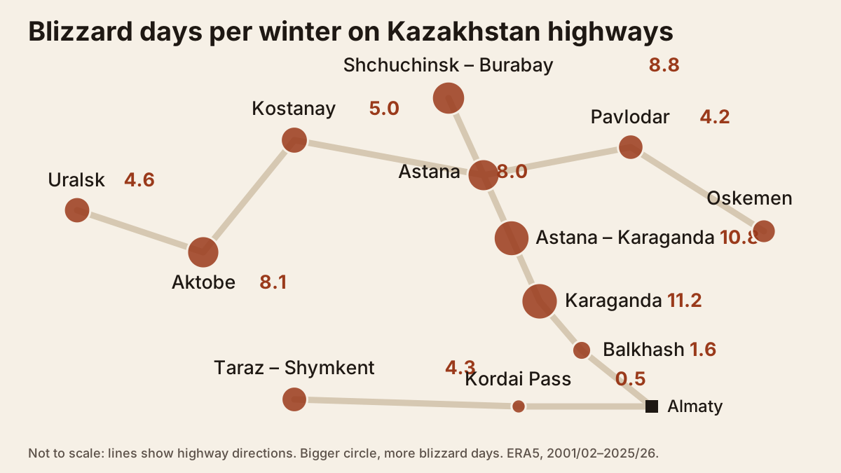
Key numbers
- 5.9 blizzard days a winter on average at each of 12 highway points. A blizzard day here means gusts of at least 54 km/h (15 m/s) plus at least 1 cm of fresh snow.
- 11.2 and 10.8: Karaganda and the Astana–Karaganda midpoint top the list, ahead of Shchuchinsk–Burabay (8.8), Aktobe (8.1) and Astana (8.0).
- March equals December: about 1.1–1.2 blizzard days in each, averaged over the 12 points. In Aktobe March is the worst month, 2.3 days.
- 2015/16 and 2023/24 were the stormiest winters, 9.8 and 9.2 days per point. The calmest was 2005/06 with 2.4.
- No proven trend. The second decade averaged 6.6 days against 5.0 in the first, but the year-to-year swing is too large to call it a real increase.
Which highways get the most blizzards
| Point | Days per winter | Gusts ≥72 km/h |
|---|---|---|
| Karaganda | 11.2 | 2.6 |
| Astana–Karaganda | 10.8 | 2.1 |
| Shchuchinsk–Burabay | 8.8 | 1.3 |
| Aktobe | 8.1 | 0.9 |
| Astana | 8.0 | 1.0 |
| Kostanay | 5.0 | 0.6 |
| Uralsk | 4.6 | 0.3 |
| Taraz–Shymkent | 4.3 | 1.5 |
| Pavlodar | 4.2 | 0.5 |
| Oskemen | 3.4 | 0.4 |
| Balkhash | 1.6 | 0.2 |
| Kordai Pass | 0.5 | 0 |
If you’re driving Astana to Burabay or Astana to Karaganda in winter, you’re on the stormiest corridor in the country. None of those points went a single winter of the 25 without a blizzard, and the Astana–Karaganda midpoint had 24 blizzard days in 2015/16.
Taraz–Shymkent, on the southern route towards Uzbekistan, is windier than it looks: 1.5 days a winter with gusts over 72 km/h, more than Astana. The strongest gust in the whole dataset, 122 km/h, hit this point on 27 December 2017.
Kordai Pass, on the Almaty–Bishkek road, scores only 0.5, but don’t trust that. The reanalysis grid cell is about 25 km wide and smooths out the pass, so it understates wind there. Russian Wikipedia notes that north-easterly winds bring blizzards to the pass that make it hard for vehicles to cross.
Month by month: March is not spring on the road
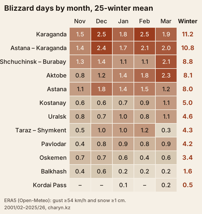
Blizzards spread almost evenly over four months: 1.14 days in December, 1.01 in January, 1.11 in February and 1.15 in March, averaged across the points. November has 0.8; October and April about 0.3.
Karaganda and the road to Astana peak in December and February, at 2.1–2.5 days. Around Aktobe and Burabay March is the worst month, with 2.1–2.3 days against 1.1–1.4 in January, and Kostanay also peaks in March. If you’re heading to Burabay in March, build in a spare day just as you would in January.
Every winter is different
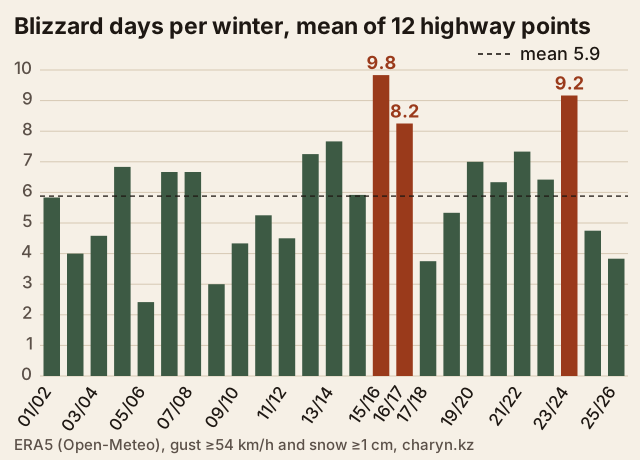
The stormiest winters were 2015/16 (9.8 days per point), 2023/24 (9.2) and 2016/17 (8.2); the calmest 2005/06 (2.4) and 2008/09 (3.0). Last winter, 2025/26, was calm at 3.8 days, yet on 22–23 February 2026 every highway in Karaganda region still closed. A single big storm is enough to stop traffic for more than a day.
| Period | Days per winter, 12-point mean |
|---|---|
| 2001/02–2010/11 | 5.0 |
| 2011/12–2020/21 | 6.6 |
| 2021/22–2025/26 | 6.3 |
The linear trend is +0.7 days per decade with an error of ±0.5, and a Mann–Kendall test gives p = 0.18, so the rise isn’t statistically proven. Shchuchinsk and Aktobe gained the most; Kostanay and Oskemen barely changed.
Do the numbers match real closures?
We found no official year-by-year record of closures, so we checked two big events reported in the news.
- 22–23 February 2026: Tengrinews reported every highway in Karaganda region closed and about 250 vehicles stuck near Ekibastuz in Pavlodar region. Our data flags 23 February as a blizzard day at Karaganda (gusts 64 km/h, 1.4 cm snow), Pavlodar (59 km/h, 3.9 cm) and Shchuchinsk.
- 22–23 January 2020: QazAvtoJol closed 47 sections, most of them in East Kazakhstan and Aktobe regions. Our data flags 6 of 12 points, including Aktobe, but not Oskemen, where 5.8 cm of snow fell with gusts of only about 40 km/h.
So the method catches windy steppe blizzards well, but misses closures caused by heavy snow without wind, ice, or drifts on mountain passes.
How road closures work
Closures on national highways are imposed by the state road operator QazAvtoJol (KazAvtoZhol) together with the police, and announced by QazAvtoJol, regional police departments and the Emergencies Ministry. A closure can be total or apply only to some vehicles: on 23 January 2020 several sections were shut only to trucks, trucks with trailers or buses. When a storm eases, police sometimes escort vehicles out in convoys, as on the Karaganda–Astana road on 23 February 2026.
How big closures get:
| When | What was reported |
|---|---|
| 23 Jan 2020 | 47 sections, 5,387 km, about 22% of national roads |
| Nov 2021 – Mar 2022 | restrictions imposed 700+ times, 125,000 calls to 1403 |
| 22–23 Feb 2026 | all highways in Karaganda region shut; 1,570 vehicles and nearly 2,000 people stuck |
| 1 Nov 2025 – 29 Jan 2026 | 908 road closures at all levels, 2,654 people evacuated |
How to check if a road is open
- Call 1403, QazAvtoJol’s free 24-hour line. We could not confirm whether operators speak English. During storms the line is busy, so call before you set off.
- QazAvtoJol and regional police channels post lists of closed sections. Ask your host or rental company to read them for you if you don’t read Russian.
- The Darmen app: in 2022 QazAvtoJol said it would push closure alerts with detour maps there.
- Kazhydromet storm warnings. A forecast of gusts of 15 m/s or more with snow is exactly what this study counts as a blizzard day, and closures followed such days in January 2020 and February 2026.
What to carry in the car
For winter 2026/27 QazAvtoJol has prepared 134 roadside heating points for 1,274 people, but a convoy on a closed section can wait for hours before it reaches one. Pack at least:
- a full tank, refuelling at every large station so you never drop below half;
- warm clothes and boots for everyone, a blanket or sleeping bag, a thermos;
- water and food for 24 hours, medicines, a charged power bank;
- a shovel, tow rope, snow brush, winter screen wash;
- the numbers 112 (general emergency) and 1403 (road status).
If you get stuck in the steppe, stay with the car; don’t walk off into a blizzard. Run the engine in short bursts and keep the exhaust pipe clear of snow.
Method
Data. Daily maximum 10 m wind gust, snowfall sum and temperature from the ERA5 reanalysis, pulled from the Open-Meteo archive with models=era5, Almaty local days, 1 July 2001 to 30 June 2026. A winter runs July to June, giving 25 winters with no gaps.
Points. Ten points sit in cities on or next to the highways, two at mid-route: Astana–Karaganda (50.45°N, 72.30°E) and Taraz–Shymkent (42.55°N, 70.45°E). Kordai Pass coordinates come from Wikipedia. Each point stands for a grid cell about 25 km across, not a particular kilometre of road.
Threshold. Blizzard day: gust ≥54 km/h (15 m/s) and snowfall ≥1 cm; strong blizzard: gust ≥72 km/h (20 m/s). Open-Meteo reports snowfall in centimetres of fresh snow. Drifting snow without snowfall, and ice, are not counted.
Scripts and raw API responses are kept in the project, so the numbers can be reproduced. Our cold map of Kazakhstan used a different wind measure (mean wind ≥40 km/h in 20 city centres), so its numbers differ, but the ranking agrees: Karaganda comes first.
Planning a winter road trip? See driving in Kazakhstan for rules and toll roads, winter in the mountains for avalanches and passes, and where Kazakhstan hits −40 °C for temperatures by city.
Cite as: “charyn.kz, from ERA5 (Open-Meteo) data, November 2026”. Data under CC BY 4.0.
Frequently asked questions
Are Kazakhstan's roads safe to drive in winter?
Which highways close most often because of blizzards?
When is the worst month for winter driving in Kazakhstan?
How do I check if a road in Kazakhstan is closed?
Can I download the data?
Sources
- Open-Meteo Historical Weather API: ERA5 (models=era5), 12 points, Jul 2001 – Jun 2026
- Copernicus Climate Data Store: ERA5 hourly data on single levels
- Wikipedia (Russian): Kordai Pass, coordinates
- Azattyq Rýhy: traffic closed on 47 sections nationwide, 23 Jan 2020 (in Russian)
- Informburo.kz: Darmen app now alerts drivers to closed roads, 4 May 2022 (in Russian)
- Tengrinews: blizzard blocks Kazakhstan highways, 23 Feb 2026 (in Russian)
- Zakon.kz: fines and arrest for driving onto closed roads, 29 Jan 2026 (in Russian)
- 24.kz: highways under special control this winter, 27 Oct 2026 (in Russian)
- QazAvtoJol national road operator, official site
- Kazhydromet: forecasts and warnings
Read also
 Where Kazakhstan hits −40°C: cold days in 20 cities over 35 years
 Can you drive in Kazakhstan with a foreign licence?
 Winter in Kazakhstan's mountains: avalanches, gear and reporting your route
 Where to go in Kazakhstan in winter
- How big is Kazakhstan? Area, borders and extreme points on the map
- Kazakhstan tiger and rewilding: a dated timeline, 2017–2026