Tamshaly canyon in Mangystau: the dripping grotto and how far it really is
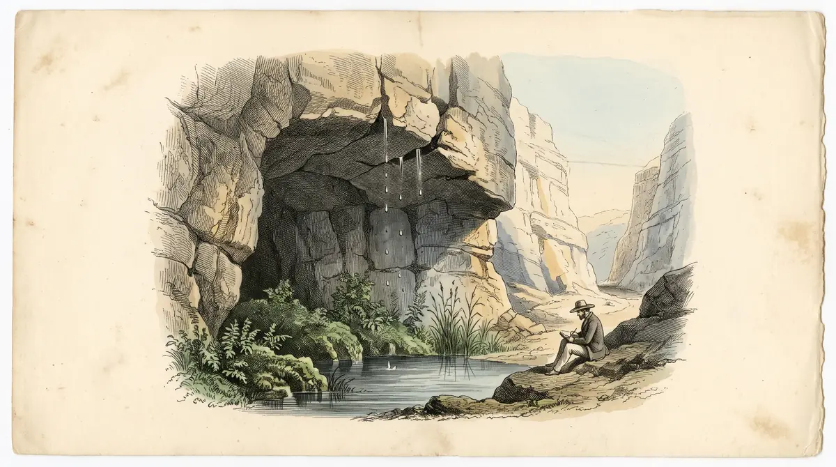
A 3 km canyon with a grotto where water drips from the roof into a small freshwater pool. Sources disagree on whether it is 35 km from Aktau or from Fort Shevchenko.
Tamshaly canyon in Mangystau: when to go, month by month
- January: possible
- February: off season
- March: off season
- April: good
- May: best time
- June: good
- July: possible
- August: possible
- September: best time
- October: good
- November: off season
- December: possible
Mid-April to late May and late September suit Mangystau. Winter brings ice columns, but access is unconfirmed.
Tamshaly canyon in Mangystau: why go
Tamshaly's dripping grotto
Water seeps through the roof in separate drops, like rain. The grotto stays cool in heat, and in winter the streams turn to ice.
A freshwater pool
A small freshwater pool and a little waterfall lie below the cliffs. We could not confirm water quality, so bring your own to drink.
Ruins and old graves
The canyon holds ancient monuments and traces of a fishing community from the early 1950s; abandoned Karagan is 3 km away.
35 km from where
The ministry counts 35 km from Aktau, while two other sources count from Fort Shevchenko. Plan a full day and check a map.
Tamshaly is a canyon and spring on the Tupkaragan peninsula in Mangystau. The name means “dripping”: water seeps through a grotto roof in separate drops and collects in a small freshwater pool. Reached by dirt road, it is usually sold as a side trip from Fort Shevchenko, and that is the base we suggest until you have checked the map yourself.
The 35 km problem
| Source | Distance | What it means |
|---|---|---|
| Tourism ministry, 2026 | about 35 km from Aktau | a short half-day |
| Welcome.kz, 2022 | about 35 km northeast of Fort Shevchenko | a full day |
| Live the World, 2022 | 35 km from Fort Shevchenko, 2.5 hours from Aktau | a full day |
All three agree on Tupkaragan District. We could not establish which reference point is right, so plan the longer day.
What you will see
The canyon runs about 3 km. In the grotto, drops falling from the roof feel like rain, it stays cool on hot days, and in winter the streams freeze into columns of ice. Below the cliffs sit the pool and a small waterfall. Mint and lemon balm grow around the old irrigated plots. You will also find ancient burial sites and the ruins of a fishing community destroyed in the early 1950s; abandoned Karagan is 3 km from the spring.
Planning the day
- Mark the point on an offline map before leaving.
- Take a 4x4, or book a guided trip in Aktau.
- Carry drinking water and watch your step: welcome.kz mentions snakes and spiders.
- Leave the graves and inscribed stones alone.
Combine with Fort Shevchenko or, further north, Zhygylgan. If you are after a swim in the sea, see the beaches near Aktau; the Mangystau guide has the regional picture.
When to go
The ministry lists Tamshaly as a summer destination, yet summer in Mangystau easily passes +40 °C. Tengrinews (2021) recommends mid-April to late May and the second half of September for the region.
Tamshaly canyon in Mangystau: tips before you go
- Save an offline map: the road is dirt and sources disagree on the reference point.
- Watch your step: welcome.kz mentions snakes and spiders.
- Leave inscribed stones alone and take your litter with you.
More to see nearby


Frequently asked questions
How far is Tamshaly from Aktau?
Do I need a 4x4 for Tamshaly?
Is the water safe to drink?
Sources
Read also
 Almaty Zoo in Kazakhstan: opening hours and how to visit
 Ayusai Gorge, Almaty: visitor centre and waterfall trail
 Gorelnik Gorge above Medeu: waterfalls, trail and season
 Kamenskoe Plateau above Almaty: observatory and trails
 Pervomaiskie Ponds near Almaty: location, swimming, season
 Saty village: base for the Kolsai and Kaindy lakes