Kumbel Peak above Almaty: height, route, season
Kumbel is a bare, rocky summit right above Almaty, 3,280 m on Kazakhstan's official list of tourist routes. It is the hardest of the standard day hikes from the city: 19–28 km, up to 2,000 m of climbing and 7–10 hours on foot.
- Getting there
- 19–28 km round trip
- Fee
- ≈ $1.40 (649 ₸) Park fee: 0.15 MCI · MCI 4,325 ₸ in 2026 · at 450 ₸ to $1 · MCI calculator
- When
- Jun–Sepbest timeNow: possible
- Altitude
- 3,280 m on the state list
- Size
- 1,700–1,987 m ascent
- Time
- 7.5–10 hours
- Note
- No water above Kok-Zhailau
Kumbel Peak above Almaty: when to go, month by month
November · now- January: possible
- February: possible
- March: off season
- April: off season
- May: possible
- June: best time
- July: best time
- August: best time
- September: best time
- October: good
- November: possible
- December: possible
June to September brings a dry trail; in winter the climb is much harder because of snow (Tengrinews guide), and spring brings avalanche risk.
Kumbel Peak above Almaty: why go
One summit, five heights
3,280 m on the state list, 3,230 m in the Tengrinews guide, about 3,200 m by guides' GPS and 3,600 m on the sign. Zabugorshiki says the last belongs to Kumbel-Tau farther along the ridge.
Three Brothers on the ridge
Three rocks taller than a person on the Sukhoy ridge, 2,860 m on the state list. The summit is 30–45 minutes on along an open ridge, and the rocks make a good turnaround point.
City and glaciers in one view
Almaty and, on clear days, Kapchagay to the north; snowy four-thousanders to the south; the Big Almaty Gorge to the west. Talgar Peak shows only on exceptional days.
Down through Gorelnik
East from the ridge over Trapezium Pass (3,272 m on the state list) into Gorelnik Gorge: 4–5 hours to the spring, where you can get a ride towards Medeu.
Kumbel Peak is the rocky summit you can see on the skyline south of Almaty, between the Big and Small Almaty gorges. Kazakhstan’s official list of tourist routes puts it at 3,280 m. It is a full-day hike: about 19 km and 7.5 hours from the Prosveshchenets bus stop, or 28 km and 8–10 hours from the Big Almaty Gorge eco-post. You don’t need ropes or an ice axe in summer, but you do need fitness, an early start and enough water.
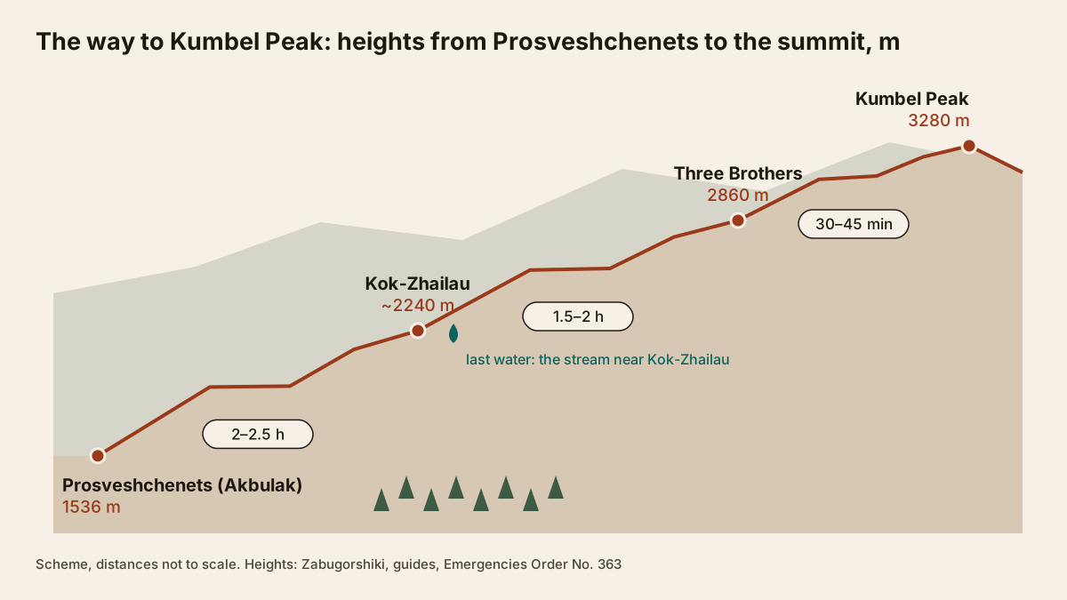
Kumbel Peak at a glance
| Height | 3,280 m (state list); 3,160–3,400 m elsewhere |
| Distance | 19 km (from Prosveshchenets) to 28 km (from the eco-post) |
| Ascent | about 1,700–1,987 m |
| Time | 7.5–10 hours |
| Best months | June to September |
| Fee | 0.15 MCI park fee at the eco-post, ≈ $1.44 (649 ₸) |
How high is Kumbel, really?
You will see five different numbers. The only official one is in the route list attached to the Emergencies Ministry’s Order No. 363: Kumbel Peak, item 54, 3,280 m, coordinates 43.120157, 77.030736. The Tengrinews guide says 3,230 m, Zabugorshiki’s guides say about 3,200 m from their GPS, and one Tengrinews route page manages to give both 3,160 m and 3,400 m.
Then there is the summit sign, which reads 3,600 m. Zabugorshiki explains that this is the height of Kumbel-Tau, a higher point farther along the ridge that a normal day hike never reaches. So if a friend tells you they “climbed 3,600 m”, they almost certainly stood next to the same sign as everyone else.
Tengrinews translates the Kazakh name as “sandy back” or “ridge” and links it to the lack of permanent snow on top. In summer it really is a grassy, stony dome with no glacier.
Three ways up
All routes meet on the ridge at the Three Brothers, three big rocks taller than a person.
| Start | Distance | Ascent | Time |
|---|---|---|---|
| Big Almaty Gorge eco-post (Tengrinews route 202) | 28 km | 1,987 m | 8–10 h |
| Prosveshchenets / Akbulak (Zabugorshiki) | 19 km | about 1,700 m | 7 h 30 min |
| Medeu via Gorelnik (Zabugorshiki) | 20 km | 1,922 m | 6 h 30 min |
Without a car, Prosveshchenets is the easiest start: city buses go there, and the walk to the plateau is covered on our Kok-Zhailau page. The eco-post start needs a car or taxi. The Gorelnik approach is quicker but its last 800 m of ascent is steep grass and scree.
The route from Prosveshchenets, step by step
Zabugorshiki breaks the day down like this:
- To Kok-Zhailau, 2–2.5 hours. Steep for the first 30–40 minutes, then easier through spruce, birch and wild apple trees.
- Plateau to Three Brothers, 1.5–2 hours. The hardest part: steep and exposed, through juniper and then over bare rock and grass.
- Three Brothers to the summit, 30–45 minutes. An open, treeless ridge with few ups and downs and big boulders near the top.
- Back down the same way, 3–4 hours.
Near the top, piles of large stones create “false summits” that make you think you’ve arrived (Tengrinews guide). The real summit is a rocky platform with a sheer drop on one side.
What you see from the top
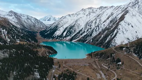
According to Zabugorshiki: Almaty to the north, and on clear days the Kapchagay reservoir; Gorelnik Gorge and the peaks of the Malaya Almatinka spur to the east, including Furmanov Peak, Panorama and Bashuta; the glaciated four-thousanders of the Ile Alatau to the south, with Talgar Peak (5,017 m) visible only on exceptional days; and the Big Almaty Gorge and lake to the west. The Tengrinews guide adds Titov, Tereshkova and Nursultan peaks to the list. The last of these is the snowy Komsomol Peak, a mountaineering objective rather than a hike.
Coming down
- The same way via Kok-Zhailau, 3–4 hours. Steep below the Three Brothers and hard on the knees; poles help.
- Via Gorelnik, 4–5 hours: east over Trapezium Pass (3,272 m on the state list) into Gorelnik Gorge and down to the spring, where a taxi can take you back towards Medeu.
- Into the Kazachka gorge, west from Kok-Zhailau to the Big Almaty Gorge. The longest option; Zabugorshiki gives no time.
When to go
Tengrinews marks route 202 as year-round, but winter is a different trip: its guide calls the summer climb one of the most accessible and the winter one much harder because of heavy snow. The comfortable window is June to September, when the trail is dry. October is possible, but snow can already lie at 3,000 m and days are short.
Spring brings avalanche risk on the gorge slopes. In March 2026 avalanches came down at 2,000–3,000 m and above in both Almaty valleys (Finance.kz, citing the emergency department). For temperatures by altitude, see mountain weather around Almaty.
Safety and what to pack
The main risks, as Zabugorshiki lists them, are the exposed, windy ridge with steep drops, afternoon cloud that can cut visibility to a few metres, running out of daylight after a long rest on the plateau, and a knee-jarring descent. They don’t recommend it for young children; fit teenagers aged 15 and over with hiking experience usually manage. Their guided day trips leave Almaty at 7 am and get back between 6 and 8 pm.
Our packing list, based on those conditions: all the water you need from the Kok-Zhailau stream, a windproof and a warm layer, a downloaded GPS track and charged phone, a headlamp, trekking poles, and microspikes in spring and autumn. Emergency numbers are 112 and, in Almaty, 109 for the city rescue service; more in our safety guide.
Notification, sign-out and fees
Kumbel and Three Brothers are on the Order No. 363 list, so a route notification applies: through eQonaq, by e-mail to the regional authority or via 112. The rules set no penalty for skipping it. The Almaty Hike service also lists both: you fill in a form before you set off and check in when you are down, and if you don’t, the emergency service starts a search. Neither the site nor Vlast (30.10.2026) calls it mandatory.
The route crosses Ile-Alatau National Park. Order No. 232 has no separate line for Kumbel; the park charges a sanitary fee of 0.15 MCI per person per day, ≈ $1.44 (649 ₸) in 2026. It is collected at the Big Almaty Gorge eco-post; guides report no fee on the Prosveshchenets side.
If Kumbel sounds like too much for a first outing, Furmanov Peak (3,053 m, 14–15 km, about 1,360 m of ascent) or Kok-Zhailau itself are gentler; more options in our guide to hiking in Kazakhstan.
Kumbel Peak above Almaty: tips before you go
- Fill up at the stream flowing off Kok-Zhailau: there is no water higher up on the Three Brothers or the ridge.
- Download a GPS track beforehand: afternoon cloud often covers the ridge and cuts visibility to a few metres.
- File a route notification via eQonaq or 112: Kumbel and Three Brothers are on the Order No. 363 list.
More to see nearby


Frequently asked questions
How high is Kumbel Peak?
How long does the Kumbel Peak hike take?
Do I need climbing gear for Kumbel?
Is there water on the trail?
Can I hike Kumbel in winter?
Do I need a permit to hike Kumbel?
Sources
- Emergencies Ministry Order No. 363, list of tourist routes, as amended 12.07.2026 (zakon.uchet.kz mirror)
- Eco-post — Kok-Zhailau — Three Brothers — Kumbel summit, route 202 — Tengrinews, 25.08.2022
- Kumbel — Tengrinews guide
- Kumbel peak day hike — Zabugorshiki
- Gorelnik — Kumbel — Zabugorshiki
- Almaty Hike service, checked 05.11.2026
- Almaty launches a sign-out service for hikers — Vlast, 30.10.2026
- Order No. 232, protected area fees, as amended 15.12.2025 (zakon.uchet.kz mirror)
- Avalanche advice — Emergencies Ministry, gov.kz, 18.02.2026
- Avalanche warning in Almaty — Finance.kz, 07.03.2026
Read also
-
Kok-Zhailau: the plateau above Almaty between the two Almaty gorges
-
Gorelnik Gorge above Medeu: waterfalls, trail and season
-
Furmanov Peak: the trail from Medeu past the Sky Swings
 Aralsk (Aral), Kazakhstan: the former port, ship graveyard and how to get there
- Astana Grand Mosque: visiting the largest mosque in Central Asia
- Baikonur launch: how tourists watch a rocket lift off