Kiin-Kerish, the Burning Cliffs near Lake Zaysan, and what a trip there takes: when to go, month by month
- January: off season
- February: off season
- March: off season
- April: possible
- May: best time
- June: good
- July: possible
- August: good
- September: best time
- October: possible
- November: off season
- December: off season
May to September is warm and fairly dry; winter is freezing, and the spring thaw and wetter autumn make the clay tracks hard to pass.
Kiin-Kerish, the Burning Cliffs near Lake Zaysan, and what a trip there takes: why go
The coloured towers of Kiin-Kerish
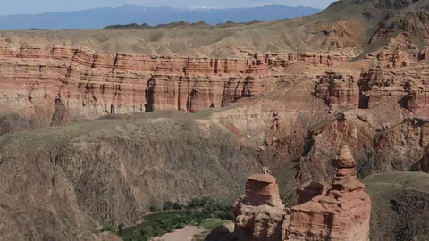
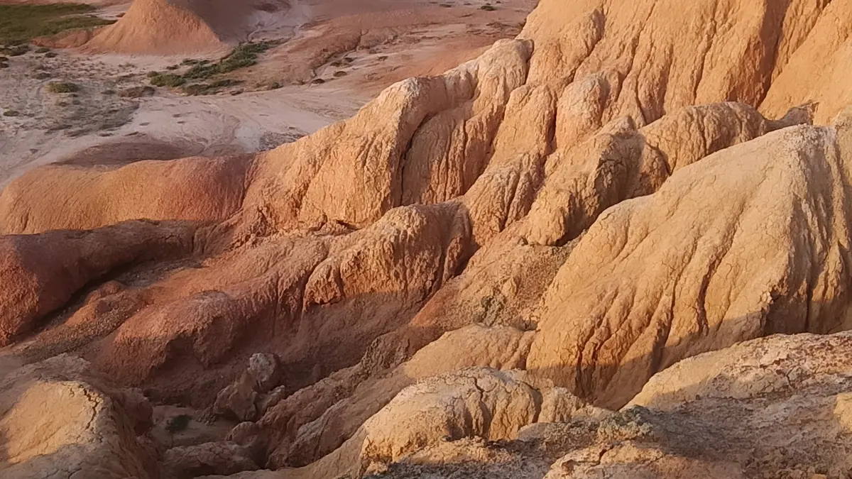
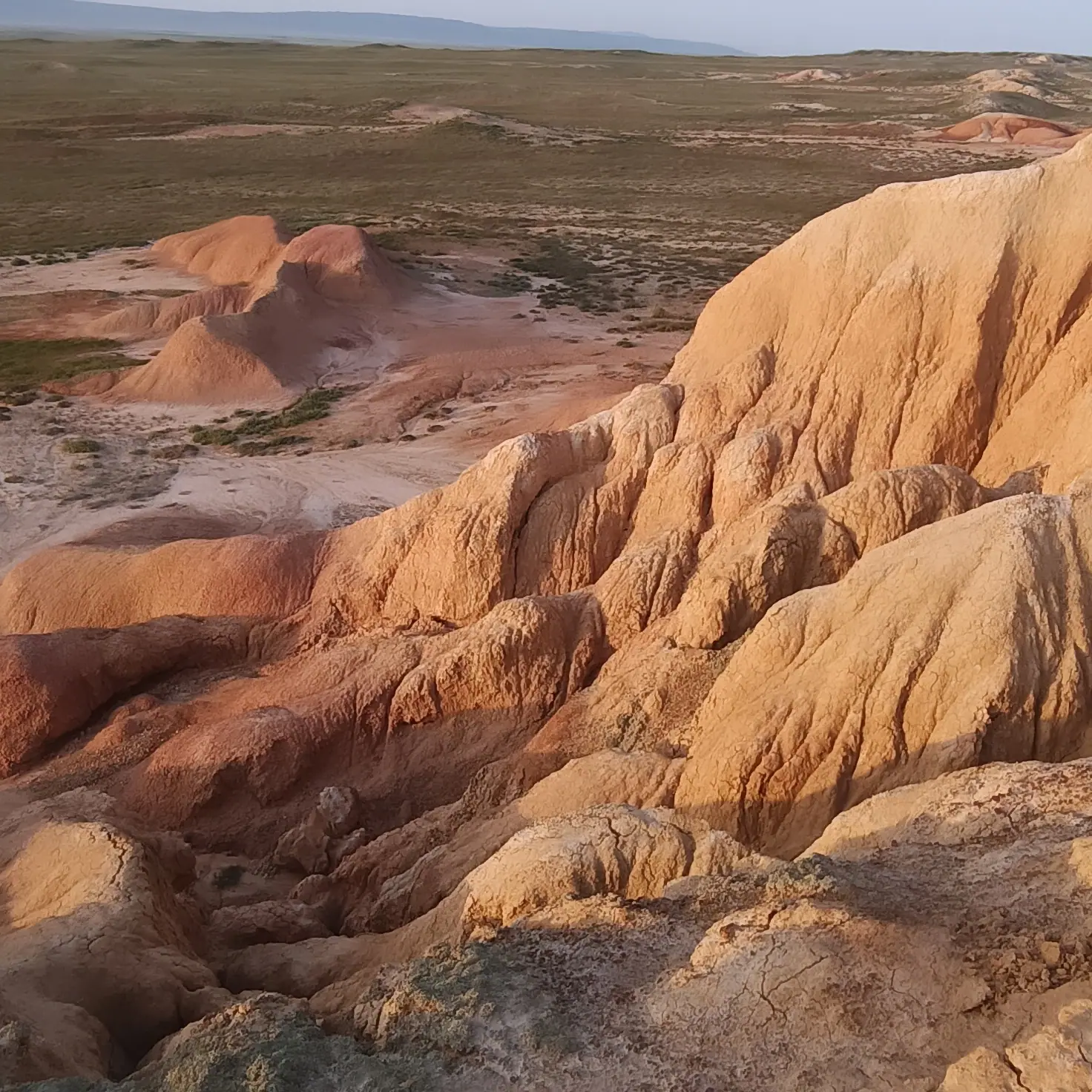
Red cliffs, humped ridges and towers of orange, white and blue clay, covering about 300 hectares in the middle of a flat desert plain.
Fossil layers in the clay
Russian Wikipedia records five plant horizons and four horizons of ancient vertebrate bones, with leaf traces of tropical flora in the clay and sand.
The long road from Oskemen
About 300 km by road: the Samar highway, the Irtysh crossing at Kulynzhon, then Kurchum and roughly 100 km more southeast to the canyon.
Kiin-Kerish in summer heat
July days average about 29 °C at the grid point; the site has no water at all, and the red ground seems to blaze in the heat, hence the Flaming Cliff name.
A name born of mud
Kazakh Wikipedia says the old name was Sharyksai and the new one recalls white clay tracks that turn to a sticky mire every spring and autumn.
Kiin-Kerish, the Burning Cliffs near Lake Zaysan, and what a trip there takes in photos
Real photos by travellers (Pexels, Unsplash, Wikimedia Commons); author and licence are given in each caption.
Kiin-Kerish, also called the Burning Cliffs, is a small canyon of coloured clay in the Kurchum district of East Kazakhstan, in the Zaysan basin. It is a protected state natural monument known for layered red, white and orange rock and for fossil leaves and bones of ancient animals. Getting there means a long drive from Oskemen and a final stretch of clay tracks that, by the Kazakh Wikipedia account, become hard to pass after rain or snowmelt.
Where Kiin-Kerish is, and how far from the cities
Kiin-Kerish lies in East Kazakhstan, about 15 km northeast of Lake Zaysan and the village of Amanat (formerly Monekey). The nearest settlement named in Russian Wikipedia is the village of Takyr. It is nowhere near Almaty: the site sits in the opposite corner of the country from the Almaty-region canyons.
| From | Distance | Type |
|---|---|---|
| Oskemen | about 300 km | by road, per Kazakh Wikipedia |
| Oskemen | about 243 km | straight line |
| Kurchum (district centre) | 95 km or 120 km | Kazakh Wikipedia gives both figures |
| Lake Zaysan / Amanat | about 15 km | per Kazakh Wikipedia |
| Semey | about 400 km | straight line |
| Taldykorgan | about 582 km | straight line |
In practice Oskemen is the likely base city, and the drive is long; the sources give no travel time. The two different figures for the distance from Kurchum appear in the same article, so treat the last leg as roughly 100 km and plan fuel and time with a margin. If you are combining this with the lake, see our page on Lake Zaysan, about 40 km away in a straight line.
What you actually see: coloured clay towers and fossil layers
The canyon is a patch of eroded badlands, about 300 hectares, set in a flat desert plain. Kazakh Wikipedia describes red-soiled cliffs, humped ridges and towers in orange, white, blue and other shades. In summer heat the reddish ground seems to shimmer like flame, which is where the local name Zhalyndy Zhar, the Flaming Cliff, and the English Burning Cliffs come from.
The scientific interest is in the layers. Russian Wikipedia records five horizons with plant remains and four horizons with fossils of ancient vertebrates, including leaf traces of tropical flora in the clay and sand.
| Item | Figure |
|---|---|
| Area | about 300 ha |
| Estimated age | 15 to 30 million years |
| Plant fossil horizons | 5 |
| Vertebrate fossil horizons | 4 |
| Status | state natural monument |
The sources are not consistent on age. Russian Wikipedia gives an estimate of 15 to 30 million years, yet in the same passage links the clays to the Mesozoic, the age of dinosaurs, which ended much earlier. Treat the dinosaur story with caution; the layered fossil record itself is the point. The site is small, so a visit is about walking the gullies and ridges for a few hours, not a multi-day hike.
Two explanations of the name Kiin-Kerish
The name has two readings, and the sources disagree. Russian Wikipedia translates Kiin-Kerish as Proud Beauty. Kazakh Wikipedia instead ties it to the word for difficult: locals say the place was once called Sharyksai, and was renamed because the white clay tracks around the hills became a sticky mire every spring and autumn, defeating riders, carts and walkers. Both agree that kerish means mountain or ridge in Turkic languages.
The second story matters to a traveller, because it describes a road problem that has a name for a reason.
Getting there: the route via Kurchum and the mud problem
The route described in Kazakh Wikipedia runs from Oskemen along the Samar highway, across the Irtysh at the Kulynzhon crossing (old name Kaznakovka), then through the village of Kurchum and on southeast to the canyon. We could not confirm any public transport to the site, so plan on a car; whether a 4x4 or a local driver is needed is unknown.
The key risk is the clay. The soil around the canyon contains white clay that dissolves in rain and snowmelt; Kazakh Wikipedia says vehicles skid and sink on the roads nearby. A wet day can turn a reachable site into an unreachable one, or strand a car on the way out. The sources say nothing about tourist infrastructure at the site.
There is no water at the site: Russian Wikipedia stresses the hot climate and the complete absence of water. Carry everything you will drink for the day.
When to go: dry late spring, early summer and September
The warmer, drier window is roughly May to September. The figures below are computed ERA5 reanalysis normals for 2011 to 2020 at a grid point at 450 m, not a weather station reading.
Day high, °C / Night low, °C · Rain/snow, mm
A computed reanalysis normal for these coordinates, not weather station records.
Monthly figures
| Month | Day high, °C | Night low, °C | Rain/snow, mm |
|---|---|---|---|
| Jan | -8.9 | -16.7 | 15.8 |
| Feb | -5.8 | -14.8 | 12.6 |
| Mar | 4.1 | -5.9 | 21.7 |
| Apr | 17.1 | 4.3 | 18.2 |
| May | 22.7 | 9.8 | 21 |
| Jun | 28.7 | 16.3 | 25.2 |
| Jul | 30 | 17.9 | 29.5 |
| Aug | 28.9 | 15.7 | 23.7 |
| Sep | 22.5 | 9.7 | 23.2 |
| Oct | 13.4 | 3.4 | 39.8 |
| Nov | 2 | -5.6 | 33.7 |
| Dec | -5.2 | -12.5 | 19.5 |
Winters are hard: January days average about -8.9 °C with nights near -16.7 °C, and the site is not a sensible winter trip. July is the warmest month, with days around 30 °C and nights near 18 °C; on bare clay with no shade or water, midday will feel hotter than that. May and September have days of about 23 to 23 °C, the most comfortable walking weather.
Rainfall is low all year, but it peaks in October (about 40 mm) and November (about 34 mm). Since the access problem is wet clay, late autumn and the spring thaw carry the highest risk of impassable tracks, which matches the local account of spring and autumn mud.
| Period | What to expect |
|---|---|
| November to March | freezing, snow and thaw mud; not sensible |
| April | cool nights near 3 °C, thaw-wet tracks possible |
| May to June | warm days, light rain; good |
| July to August | hottest, around 28 to 29 °C, no shade or water |
| September | days near 21 °C; good |
| October | wettest month; high mud risk |
Plants, animals and protected status
Kiin-Kerish is a state natural monument and is listed as one of eleven sacred places of East Kazakhstan region, according to Kazakh Wikipedia. Treat it accordingly: stay on existing tracks and do not take rocks or fossils.
Besides saxaul, the sources name two regionally protected plants, Krylov’s ferula and grey atraphaxis; some ferula species yield galbanum, an aromatic resin. Kazakh Wikipedia also mentions the diversiform poplar. Among animals, the yellow steppe lemming found here is in the Red Book of Kazakhstan. If you want a contrast in landscape on the same side of the country, the Rakhmanov Springs in the Altai are about 214 km away in a straight line. Charyn Canyon, in the Almaty region, is covered on a separate page.
- Current condition of the final road from Kurchum to the canyon and whether a 4x4 is needed
- Any public transport or shared taxis from Oskemen or Kurchum towards the site
- Visiting rules, fees or permits for the state natural monument
- Whether there is any shelter, signage or mobile signal at the canyon
Kiin-Kerish, the Burning Cliffs near Lake Zaysan, and what a trip there takes: tips before you go
- Check the weather for the days before you go: the white clay roads near the canyon become slick and cars sink after rain or snowmelt.
- Carry all drinking water for the day; sources stress there is no water at Kiin-Kerish, and July days average about 29 °C.
- Plan for Oskemen as your base: it is about 300 km by road, so leave early and allow for the slow final stretch past Kurchum.
- Avoid October and November if you can: they are the wettest months in the climate data, with about 37 and 31 mm, raising the mud risk.
More to see nearby