Eshkiolmes Petroglyphs: over 4,000 rock carvings on a Zhetysu ridge
A low mountain ridge in south-east Kazakhstan holds more than 4,000 well-preserved rock carvings, along with burial mounds and old camp sites. This page sets out what is known about it and what you will need to check before you go.
Eshkiolmes Petroglyphs: when to go, month by month
- January: possible
- February: possible
- March: possible
- April: good
- May: good
- June: good
- July: possible
- August: possible
- September: good
- October: good
- November: possible
- December: possible
An estimate based on the site type, not on climate data: exposed dry rock and steep ravines suggest spring and autumn, but confirm local conditions before going.
Eshkiolmes Petroglyphs: why go
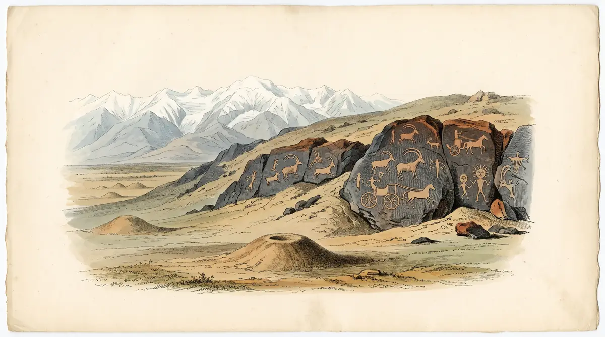
Eshkiolmes rock art panels
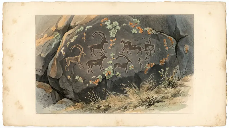
More than 4,000 well-preserved carvings in many techniques, some detailed enough to show the clothes and tools of the people who made them.
Andronovo herders on the Koksu
In the 2nd millennium BC, Andronovo-culture tribes farmed, herded cattle and sheep and smelted copper along the right bank of the Koksu river.
Reaching Eshkiolmes
No confirmed public transport. Plan for a driver or guide, and name the Talapty depression to avoid villages also called Eshkiolmes.
Dry ravines, open rock
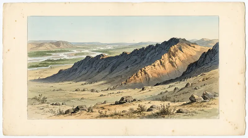
The steep southern slope is cut by waterless ravines. With no climate data confirmed, check local weather and carry your own water.
A name meaning year-round pasture
Kazakh herders give the name Eshkiolmes to land that can be grazed all year, which is why it appears on maps across Kazakhstan.
The Eshkiolmes petroglyphs are a large field of rock art spread along the Eshkiolmes range in the Zhetysu Alatau foothills of south-east Kazakhstan. More than 4,000 well-preserved carvings survive there, mostly from the Bronze Age, and some are detailed enough to show clothing and tools. It is a trip for travellers interested in archaeology who are ready to organise their own transport, because practical access information is scarce.
What the Eshkiolmes petroglyphs are
The site is a complex of rock carvings on the cliffs of the Eshkiolmes ridge, set among Late Bronze Age to medieval settlements and burials. Wikipedia counts more than 4,000 surviving petroglyphs, made with a wide range of techniques. Some show minute details of ancient life, down to clothes and tools.
The carvings are only one layer. The Kazakh Wikipedia also lists burial mounds (kurgans), ritual enclosures beside them, stone statues, balbal stones, clan marks (tamgas) and carved inscriptions. If you only want a few dramatic panels, this is a slow site. If you like reading a landscape, there is a lot here.
| Key point | What sources say |
|---|---|
| Number of petroglyphs | More than 4,000, well preserved |
| Age of the rock art | 13th–9th century BC (Russian Wikipedia); Bronze Age (Kazakh Wikipedia) |
| Location | Eshkiolmes ridge, Zhetysu Alatau, Aksu district of Zhetysu region (Kazakh Wikipedia); Almaty region (English Wikipedia) |
| Main panel found | 1982, western part of the Talapty depression |
| UNESCO status | Tentative List, Mixed (Cultural + Natural), 1998 |
| Kazakh status | State list of local historical and cultural monuments, Zhetysu region |
The two region names in the table describe the same place. English and Russian Wikipedia say Almaty region, while Kazakh Wikipedia says Zhetysu region, so use the ridge name rather than the region when you search on a map.
Three thousand years of people on one ridge
Eshkiolmes was used by successive groups over a very long span, and the carvings record several of them. The earliest known inhabitants were Andronovo-culture herders and farmers of the 2nd millennium BC. They settled along the right bank of the Koksu river and its tributaries, especially on the southern foothills of the range, where large settlements and cemeteries have been found.
| Period | Who | Evidence |
|---|---|---|
| 2nd millennium BC | Andronovo-culture tribes | Settlements and cemeteries; finds show simple farming, cattle and sheep herding, copper smelting |
| Bronze Age | Same communities | Bone arrowheads, a sling and wild animal bones point to hunting, which also appears in the rock art |
| Medieval | Nomads | Camp sites, burials |
| 17th–early 20th century | Oirats, and the Alban and Zhalair of the Kazakh Senior Zhuz | Camp sites, clan marks and inscriptions on nearby rocks |
The Kazakh Wikipedia calls the tamgas and inscriptions a chronicle of the nomads who replaced one another in the Koksu valley, in peace and in conflict. The main panel was found in 1982 and has been studied for many years by archaeologists A. N. Maryashev, A. E. Rogozhinsky, A. A. Goryachev and others.
Why the south slope matters
The ridge is lopsided, and the steep southern side is where the archaeology concentrates. The northern slope is gentle, with few hills and thick grass, while the southern one is steep and cut by a chain of deep, narrow, rocky ravines that are poor for grazing or living.
Nomads camped at the heads of these dry ravines, near the watershed of the ridge, where they were sheltered from cold winter winds. The name itself reflects herding life. According to the Kazakh Wikipedia, Eshkiolmes is a common place name in Kazakhstan, given by herders to land that can be grazed all year round.
For a visitor this means rough, broken ground and no water in the ravines. We could not confirm whether there are marked paths.
Getting to Eshkiolmes: what we could not confirm
We could not confirm a road route, a driving time or any public transport to the petroglyphs. Without that, plan this as a trip with a private driver or a local guide, not as a bus trip. The site lies on the Eshkiolmes ridge in Aksu district, in the Koksu river basin of the Zhetysu Alatau. Sources do not give its distance from Almaty.
Check the name carefully when you book or search. Several unrelated places are called Eshkiolmes: a village in Eskeldi district, a village in Sarkand district (called Sokolovka until 2018), and a gold deposit in Akmola region. A driver who hears only the name may head for the wrong one, so give the Talapty depression or the Koksu valley as a reference.
Finding someone who knows the exact panels is likely to be the hardest part of this trip. With over 4,000 carvings spread along a ridge, local knowledge decides whether you see the main panels or just rock.
When to go
We have no climate data for the ridge, so treat any seasonal advice here as an estimate. The ravines are dry and the main panels are on open rock. Confirm local conditions before you go. Ask locally about snow on the access road in winter and about heat in midsummer.
Visiting with care
Eshkiolmes is on the state list of historical and cultural monuments of local significance, and the carvings sit among burials. Treat it as you would a cemetery and a museum at once. Do not touch, chalk, wet or trace the carvings to make photos clearer, and do not move stones around kurgans or enclosures. Low side light shows the engraved lines better than any of these.
- Road route, driving time and distance from Almaty or Taldykorgan to the petroglyphs
- Whether any public transport reaches the nearest village
- Whether entry is free or ticketed, and whether a guide or permit is required
- Whether there are marked paths or signs to the main panels
- Typical weather and road conditions by season on the ridge
Eshkiolmes Petroglyphs: tips before you go
- Search for the Eshkiolmes ridge or Talapty depression, not just 'Eshkiolmes': two villages and a gold deposit share the name.
- The main panel was found in 1982 in the western Talapty depression, so ask your driver or guide to take you there first.
- The southern ravines are dry, so carry all the water you will need for time on the slope.
- Photograph in low side light rather than wetting or chalking the carvings; the site is a protected state monument.
Frequently asked questions
Where are the Eshkiolmes petroglyphs?
How old are the Eshkiolmes petroglyphs?
How many petroglyphs are there at Eshkiolmes?
Is Eshkiolmes a UNESCO World Heritage Site?
Who made the Eshkiolmes rock carvings?
Sources
Read also
 Turkestan: the Yasawi Mausoleum, Sauran and Otrar
 Arystan Bab Mausoleum, the pilgrim stop before Turkistan
- Ancient cities of Kazakhstan: nine sites and what is left to see
- The Silk Road in Kazakhstan: three corridors and where to see them
 Akyrtas: the unfinished red stone palace east of Taraz
 Otrar, the Silk Road city in southern Kazakhstan that fell to Genghis Khan