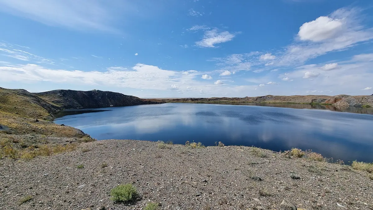
Chagan Atomic Lake, the crater a 1965 nuclear blast left on the Semipalatinsk Test Site: when to go, month by month
- January: off season
- February: off season
- March: off season
- April: possible
- May: best time
- June: good
- July: good
- August: good
- September: best time
- October: possible
- November: off season
- December: off season
Winters are severely cold with highs well below freezing, so late spring to early autumn is the sensible window, with June and September avoiding the peak heat.
Chagan Atomic Lake, the crater a 1965 nuclear blast left on the Semipalatinsk Test Site: why go
The crater of Chagan Atomic Lake
A round lake 400 m across and about 100 m deep, ringed by a rim 20 to 38 m high thrown up by the 1965 underground explosion.
A nuclear blast for reservoirs
The Chagan test was followed by a plan for about 40 nuclear-made reservoirs in Kazakhstan, holding 120 to 140 million m³ of spring meltwater in total.
Semey as the base
Semey is about 102 km in a straight line from the lake. We could not confirm public transport, so plan on arranged transport and a guide from there.
Steppe summer at Chagan
From May to September day highs average 20 to 28 °C, with July the warmest; January highs sit near -11 °C and nights near -20 °C.
Fallout detected over Japan
About 20% of the radioactive products were estimated to have escaped the blast zone and were detected over Japan, angering the US over the 1963 test ban treaty.
Chagan Atomic Lake, the crater a 1965 nuclear blast left on the Semipalatinsk Test Site in photos
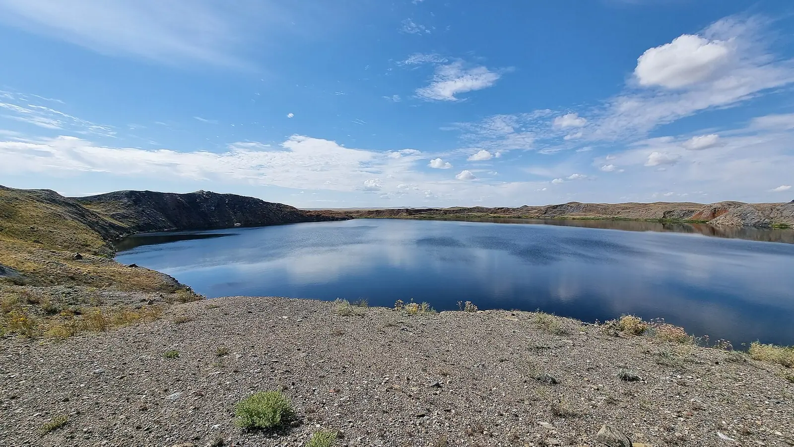
Real photos by travellers (Pexels, Unsplash, Wikimedia Commons); author and licence are given in each caption.
Chagan Atomic Lake (Shagan, also called Balapan) is a crater lake in Abai Region of eastern Kazakhstan, created on 15 January 1965 by a Soviet underground thermonuclear explosion. It sits on the Balapan complex of the former Semipalatinsk Test Site, about 102 km in a straight line from Semey, and its water remains contaminated with radionuclides. It is a history site for people interested in the nuclear age, not a place for swimming or a lakeside rest.
What Chagan Atomic Lake is and where it lies
The Atomic Lake is a flooded explosion crater in the steppe of Zhanasemey District, Abai Region. English Wikipedia places it 90 km south of the Irtysh and about 110 km southwest of Semey (formerly Semipalatinsk); our own straight-line calculation gives about 102 km from Semey. It lies north of the confluence of the Shagan river and its north-flowing tributary, the Ashchysu.
For scale against the bigger cities: Oskemen is about 259 km in a straight line, Pavlodar about 298 km and Karaganda about 423 km. Semey is the nearest city in our data, so it is the practical starting point for anyone heading here.
| Key figure | Value |
|---|---|
| Formed | 15 January 1965 |
| Device yield | 140 kilotons |
| Depth of charge | 178 m, borehole No. 1004 |
| Crater | 400 m across, about 100 m deep |
| Rim height | 20 to 38 m |
| Volume | about 10 million m³ (English Wikipedia) or 19.1 million m³ (Kazakh Wikipedia) |
| Area | 5.92 km² (Kazakh Wikipedia) |
The two volume figures differ by almost double, and we could not confirm whether the larger one includes the reservoir south of the crater. Read the table as orders of magnitude, not survey data.
The 1965 Chagan test: a nuclear explosion meant to build reservoirs
The lake was the result of the Chagan test, run under the Soviet programme of Nuclear Explosions for the National Economy. A 140 kiloton device was placed 178 m down in the dry bed where the Shagan and Ashchysu rivers meet, and fired at 05:59:59 GMT on 15 January 1965.
The idea, according to Russian Wikipedia, was to create about 40 artificial water bodies in Kazakhstan with nuclear blasts, holding 120 to 140 million m³ in total. Deep basins with melted bottoms and a small surface would store spring meltwater and lose little to evaporation. Kazakh Wikipedia notes bluntly that the calculations failed: the water is still contaminated and unfit to drink.
In early 1965 a canal joined the Shagan river to the new crater. A few years later an earth-and-rock dam with water outlets was built on the left bank, and the crater rim now holds back a two-lobed reservoir to the south. English Wikipedia says that reservoir still provides water for local cattle.
The test also had an international echo. Some 20% of the radioactive products were estimated to have escaped the blast zone and were detected over Japan, which angered the United States as a breach of the October 1963 Limited Test Ban Treaty.
The water is radioactive: what that means for a visit
The lake water is about 100 times above the permitted level of radionuclides, according to English Wikipedia. Both Russian and Kazakh Wikipedia describe it as heavily contaminated and not drinkable. Locals still fish there, despite warnings from the authorities that it is hazardous.
The lake appears in the Netflix series Dark Tourist (season 1, episode 4, “The Stans”), where presenter David Farrier swims in it and eats a fish from it. That is television, not a safety standard. Do not drink the water, do not swim and do not eat local fish from the lake.
What we could not confirm is the more important part for planning: current radiation levels on the shore and rim, whether visitors are allowed to walk up to the water, and what rules apply to entering the former test site. English Wikipedia calls the Balapan complex one of the main tourist attractions of the Semipalatinsk Test Site, but gives no access conditions. Ask these questions in Semey before committing to the trip.
Getting there from Semey
Semey is the closest city in our data, about 102 km in a straight line, so a visit is a day trip from there at best. Road distance, road condition and travel time are not in our sources, and we could not confirm any public transport to the site.
For a traveller without a car or Russian this is a hard place to reach independently. The site is a former military test ground, and we could not confirm the access rules, so it helps to go with someone who knows them. Plan on arranging transport and a knowledgeable guide in Semey rather than improvising.
If you are building a longer trip through eastern Kazakhstan, other places on this site are far from the lake: Lake Zaysan is about 423 km in a straight line, and the Rakhmanov Springs in the Altai about 541 km. Neither is a same-day add-on.
When to go: hot summers, very cold winters
The climate figures below are computed normals for 2011–2020 from the ERA5 reanalysis at a grid point at 307 m, not readings from a weather station.
Day high, °C / Night low, °C · Rain/snow, mm
A computed reanalysis normal for these coordinates, not weather station records.
Monthly figures
| Month | Day high, °C | Night low, °C | Rain/snow, mm |
|---|---|---|---|
| Jan | -11.2 | -20.1 | 9.4 |
| Feb | -8.3 | -18.4 | 12.5 |
| Mar | 1.5 | -8.9 | 22.2 |
| Apr | 15.7 | 2.1 | 19.1 |
| May | 20.9 | 7 | 23.4 |
| Jun | 26.9 | 14.2 | 31.1 |
| Jul | 27.9 | 15.7 | 49 |
| Aug | 26.5 | 13.1 | 31.6 |
| Sep | 19.8 | 6.5 | 19 |
| Oct | 11.1 | 0.5 | 28.1 |
| Nov | -0.8 | -9.2 | 26.4 |
| Dec | -7.4 | -16 | 14.8 |
This is a sharply continental steppe. In January daytime highs average about -11.2 °C and nights about -20.1 °C; even March barely gets above freezing by day. From May to September highs run between about 20 and 28 °C, with July the warmest at about 27.9 °C and nights around 16 °C.
Rain is light all year, peaking at about 49.0 mm in July, so the main summer issue is heat and sun on open ground with no shade. May, June, August and September are a little milder than July for a long day out on the steppe.
| Period | Typical day high | What to expect |
|---|---|---|
| Dec–Feb | -11 to -7 °C | Deep frost, hard travel |
| Mar | about 2 °C | Cold, thaw beginning |
| Apr | about 16 °C | Cool, nights near freezing |
| May–Sep | 20 to 28 °C | Comfortable to hot |
| Oct | about 11 °C | Cooling fast, nights near 1 °C |
| Nov | about -1 °C | Winter returns |
For most visitors the table means one thing: avoid November to March unless you are prepared for serious cold far from any town.
- Whether visitors need a permit or escort to enter the former Semipalatinsk Test Site
- Current radiation levels at the shore and crater rim, and how close visitors may go
- Road distance, road condition and driving time from Semey
- Whether any public transport reaches the area
- Whether there is any shelter, water or facilities on site
Chagan Atomic Lake, the crater a 1965 nuclear blast left on the Semipalatinsk Test Site: tips before you go
- Do not drink, swim in or fish from the lake: the water is about 100 times above the permitted radionuclide level.
- Ask in Semey about current access rules for the former Semipalatinsk Test Site before you set off; we could not confirm them.
- Avoid November to March: average January highs are about -10.7 °C, far from any town on open steppe.
- On a summer day trip carry sun protection and water: July highs average about 27.6 °C and the steppe here has no shade.
More to see nearby


Frequently asked questions
How was the Atomic Lake formed?
Can you swim in Chagan lake?
How far is the Atomic Lake from Semey?
Why is it also called Balapan?
How big is Chagan Atomic Lake?
Sources
Read also
 Almaty Zoo in Kazakhstan: opening hours and how to visit
 Ayusai Gorge, Almaty: visitor centre and waterfall trail
 Gorelnik Gorge above Medeu: waterfalls, trail and season
 Kamenskoe Plateau above Almaty: observatory and trails
 Pervomaiskie Ponds near Almaty: location, swimming, season
 Saty village: base for the Kolsai and Kaindy lakes